Introduction to Big Sur
The name "Big Sur" is derived from the original Spanish-language "el sur grande", which translates as "the big south", or from "el país grande del sur", "the big country of the south". And so it seemed to early settlers in Monterey. The coastal area to their south was huge and unexplored, and its coastline was especially treacherous to ships.
Some people assume that Big Sur is a state or national park. Though there are state parks in Big Sur, including two with the word "Sur" in their names, they cover only a small fraction of the Big Sur region of the central California coast, and much of what there is to see and do in Big Sur is not in any of the state parks.
Where is Big Sur?
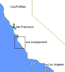
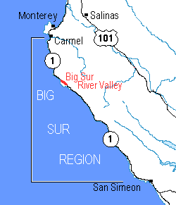
The Big Sur region, about 89 highway miles (143 km) in length along California's coastal Highway 1, lies between the San Francisco Bay area and the Los Angeles area. For the purposes of this guide, the Big Sur region's northern end is at Carmel, approximately 130 road miles (210 km) south of San Francisco and adjacent to Monterey. Its southern end is at San Simeon, approximately 240 road miles (385 km) north of Los Angeles and near Cambria, Morro Bay, and San Luis Obispo.
Like many others, I think of this entire stretch of coastline, together with the western slopes of the Santa Lucia mountain range to the east, as "Big Sur". To some others, "Big Sur" means only the lower valley of the Big Sur River, where there is a U.S. Post Office in "Big Sur, California 93920". (There are no borders of this Big Sur, however, because there is no officially-established city or town, just unincorporated county land.) To still others, "Big Sur" means Pfeiffer Big Sur State Park and nothing more. (This amuses me because the atmosphere and physical setting of that state park is very different from the rocky coastal environment that means "Big Sur" to many others.) So I suggest that travelers recognize and understand all those uses of the term "Big Sur". The ambiguity fits the relaxed nature of the region.
Highway 1's history in Big Sur can be traced back to 1872, when a wagon road was built south from Monterey to Bixby Creek. It was not until 1919 that California's voters approved bonds to build a modern road. Construction began in 1922, and Highway 1 was officially opened through the Big Sur region in 1937 with the completion of Big Creek Bridge in the southern Big Sur region.
The Big Sur Mystique
Why does Big Sur intrigue so many people? There is the magnificent coastal scenery, of course. But the region has a colorful recent human history (some of it in books and on film) that is of interest:
- 1944: Filmmaker and film actor Orson Welles (Citizen Kane, 1941) and his then-wife, film star Rita Hayworth (62 films including You Were Never Lovelier, 1942, opposite Fred Astaire), jointly purchased a log cabin for use as a refuge from the pressures of Hollywood. The property is now the location of Nepenthe Restaurant, whose Web site has a fuller version of this story.
- 1957: The book Big Sur and the Oranges of Hieronymus Bosch, by artist and writer Henry Miller, was published. It is the story of Miller's life in the Big Sur region. Miller had arrived in Big Sur in 1944. (See also the Books and Maps page.)
- 1957: The Hearst Corporation donated Hearst Castle® to the State of California, ten years after William Randolph Hearst last visited the area. The first tours of the property were offered to the public in 1958.
- 1961: The Big Sur Master Plan, said to be the first of its kind for the protection of scenic values, was adopted by Monterey County.
- 1962: Esalen Institute, a leader in the human potential movement, was founded on the central Big Sur coast, incorporating cliffside hot springs. Abraham Maslow (humanistic and transpersonal psychology), Fritz Perls (Gestalt therapy), and Will Schutz (the bestseller Joy; encounter groups) all influenced Esalen's early years.
- 1962: The novel Big Sur, by Beat Generation author Jack Kerouac, was published. The novel is set in San Francisco and in Big Sur's fictional "Raton Canyon" (said to be modeled after Bixby Canyon) during the summer of 1960 and describes the author's own mental breakdown. (See also the Books and Maps page.)
- 1965: The film The Sandpiper, starring Elizabeth Taylor and Richard Burton, was released. Filmed in Big Sur, it portrays a boy and his free-spirited, unwed mother (Taylor) living an idyllic lifestyle in Big Sur. An Episcopalian priest (Burton) initially disapproves of the mother, but eventually they have an illicit affair.
- Mid to late 1960s: Possibly inspired by The Sandpiper even more than by Kerouac, hippies arrived in large numbers in Big Sur.
Today Big Sur retains some effects of all these influences but is above all slow-paced, low-key, remote, and mostly natural. Seen from Big Sur, the concept of growth and development that drives most modern American communities seems to belong on some other planet. And rightly so.
"In the end, our society will be defined not only by what we create but by what we refuse to destroy."

